10:35PM: The burden for above normal warmth has shifted to the southeastern US for the time being. Instead of heat out west, there is a chance for mountain snow early next week in the northern Rockies.
from Victoria-Weather

10:35PM: The burden for above normal warmth has shifted to the southeastern US for the time being. Instead of heat out west, there is a chance for mountain snow early next week in the northern Rockies.
7:35PM: There is a “minor heat risk” for the Central Valley in California. At least it’s minor. But what’s this? There is also a winter weather advisory in the Sierras. California contains multitudes.
We have finally left California, and now we head to the opposite coast. We don’t see enough of Baltimore, if you ask me. The Inner Harbor is wonderful.
At 1054PM, ET, Baltimore was reporting a temperature of 43 degrees with clear skies. The DC and Baltimore reporting sites were anomolous to the region, with temperatures in the mid to upper 30s nearby. Clear skies and low dew points suggest that Baltimore will see a chilly morning tomorrow. There are freeze warnings out regionwide.
The pattern is conducive to a spring cool down, with a subtropical low in the Bight of Georgia and high pressure centered over the eastern Great Lakes. An upper level ridge is close behind, however, and while Wednesday will start cool, it will warm up nicely. Thursday looks like it could be spectacular.
Tomorrow – Sunny, High 54, Low 30
Thursday – Sunny, High 62, Low 36
TWC: Tomorrow – Sunny High 54, Low 33
Thursday – Partly cloudy skies. High 61, Low 37
AW: Tomorrow – Plenty of sun, but cool High 52, Low 32
Thursday – Times of clouds and sun High 58, Low 37
NWS: Tomorrow – Areas of frost before 9am. Otherwise, sunny High 53, Low 33
Thursday – Mostly sunny, High 59, Low 38
WB: Tomorrow – Areas of frost in the morning. Sunny. High 50, Low 34
Thursday – Areas of frost in the morning. Mostly sunny High 54, Low 35
WN: Tomorrow – Sunny with areas of frost, High 53, Low 33
Thursday – Partly cloudy, High 59, Low 38
CLI: Tomorrow – Sunny, High 54, Low 34
Thursday – Mostly cloudy, High 57, Low 37
I’m the most optimistic about the power of insolation, it appears. Time will tell. Right now, clear skies on the coast, with clouds off shore.
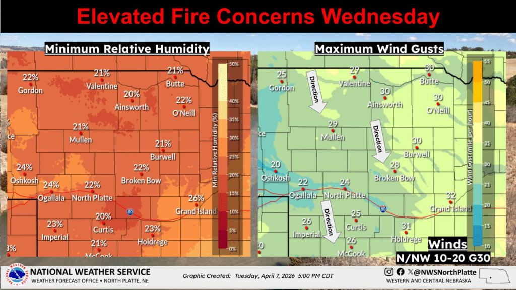
12:05AM: A full week into April now, and we are definitely in severe season. If it were a busier pattern. Instead, the concern is going to be fire in the Plains.
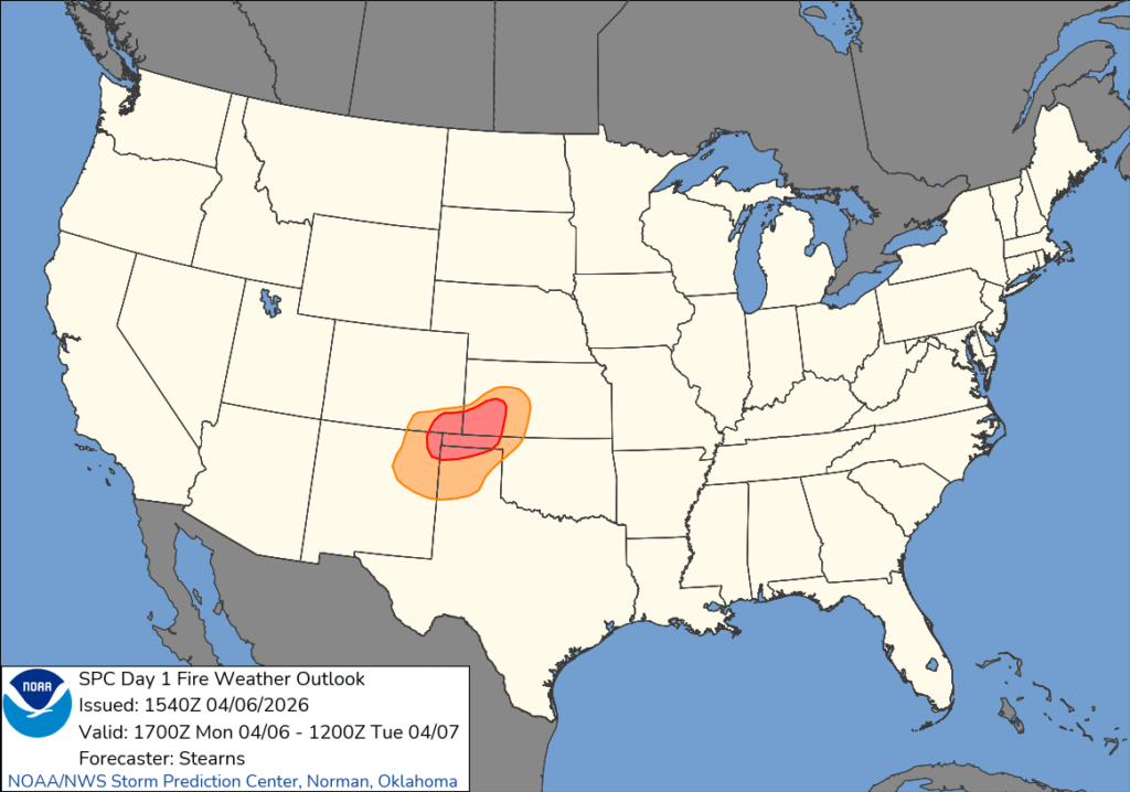
6:23PM: The concern for fire in the Plains is shifting a bit further north. Here is the outlook from NWS North Platte.
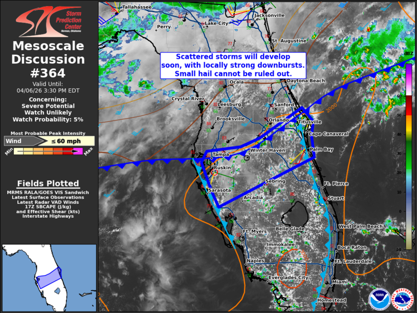
1:50PM: The map is pretty quiet today. The closest thing to action is this area, being watched by the SPC in Florida. The area could use the rain, so as long as the activity isn’t severe, this might qualify as good news.
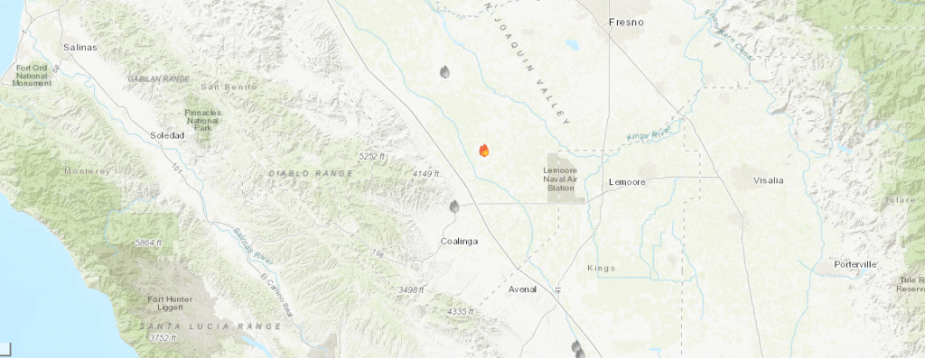
7:10PM Happy Easter! One thing to appreciate on this day is that, despite fires developing in California, they have been well contained and remain small. We forecast for Visalia last night, and today, west of town, this little fire, the Lake fire popped up.Not a major concern, but worth noting.
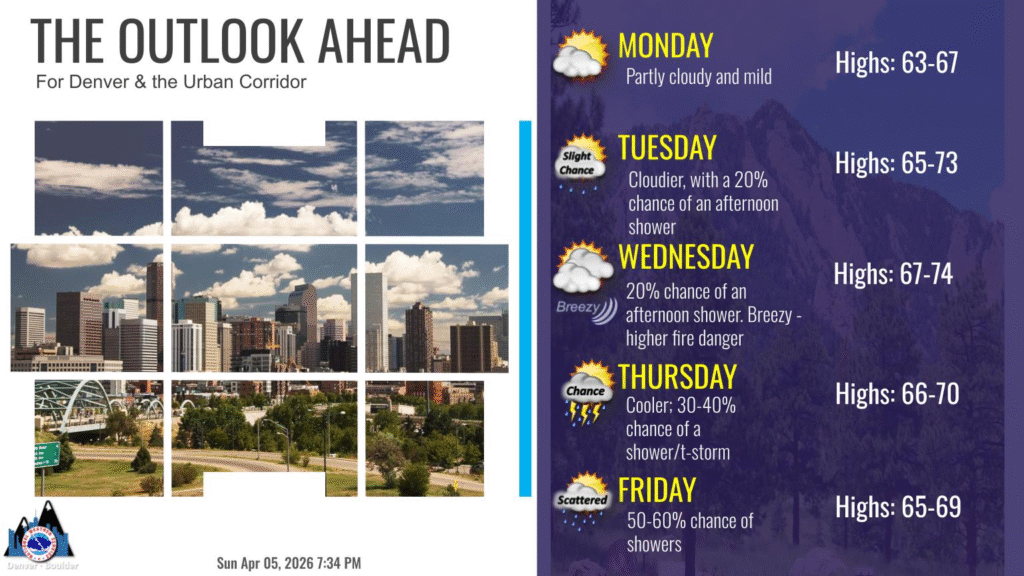
9:11PM High pressure and a slow moving pattern is the story in the west. The forecast from Denver tells the story.
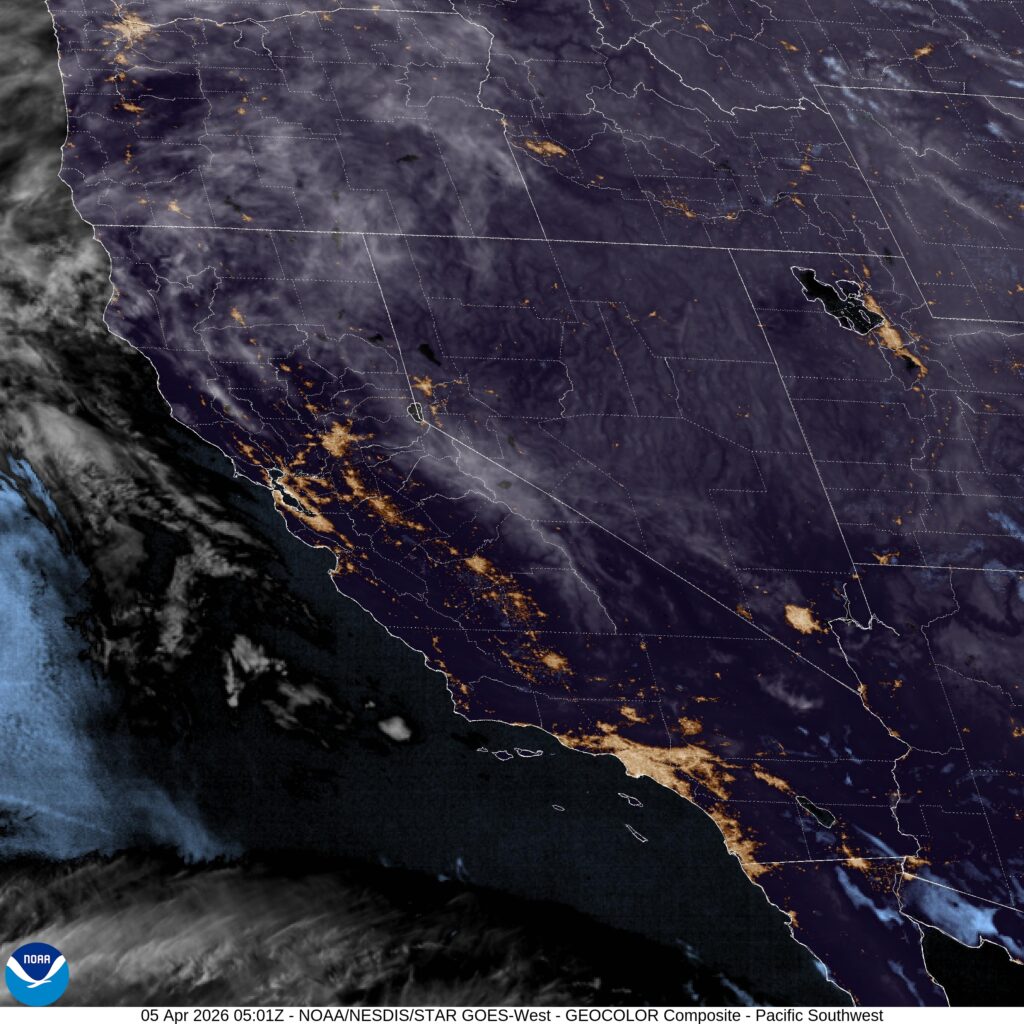
Our string of visits to California continues with a late visit to the central Valley.
At 956PM, PT, Visalia was reporting a temperature of 67 degrees with clear skies. Dew points are in the 40s through the Valley, and even higher to the north, suggesting a chance for fog in the morning. The higher dew points and cooler evening temperatures are a result of very pleasant early April temperatures.
There is a jet streak running along the Mexican border that is bearing the load of keeping the oppressive heat at bay, while a strong ridge through the Pacific Northwest ensures that California will enjoy continued sunny skies from Easter into the beginning of the work week.
Tomorrow – Sunny, High 86, Low 51
Monday – Sunny, a bit of haze in the morning, High 85, Low 52
TWC: Tomorrow – Sunny, along with a few afternoon clouds High 89, Low 49
Monday – Partly cloudy skies. High 87, Low 54
AW: Tomorrow – Mostly sunny and very warm with the temperature approaching the record high of 90 set in 1960 High 87, Low 48
Monday – Mostly sunny and very warm High 87, Low 52
NWS: Tomorrow – Sunny High 86, Low 51
Monday – Sunny High 86, Low 54
WB: Tomorrow – Sunny High 87, Low 53
Monday – Sunny High 86, Low 57
WN: Tomorrow – Mostly Sunny, High 86, Low 52
Monday – Mostly Sunny, High 86, Low 54
CLI: Tomorrow – Sunny, High 87, Low 49
Monday – Sunny, High 86, Low 52
Mid 80s compared to what had been seen recently out west does seem pretty manageable, despite, as Accuweather noted, these highs being close to records. There are some clouds in the Sierras, but a clear night elsewehre.
11:32PM: Today is the beginning of April. Broadly, what are we thinking? Well, warm, too be sure, but less than oppressive. The CPC has the outlook:
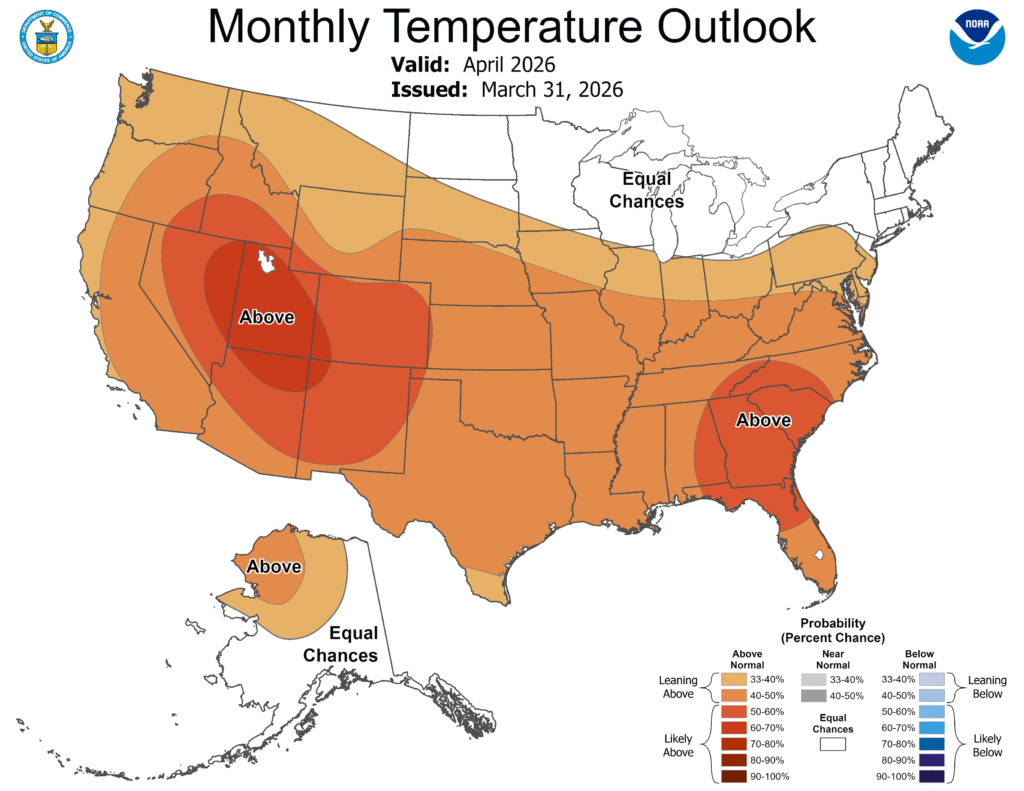
Precipitation shows a threat for above average rain particularly in the mid-Mississippi Valley.
12:30AM: Cold Front!
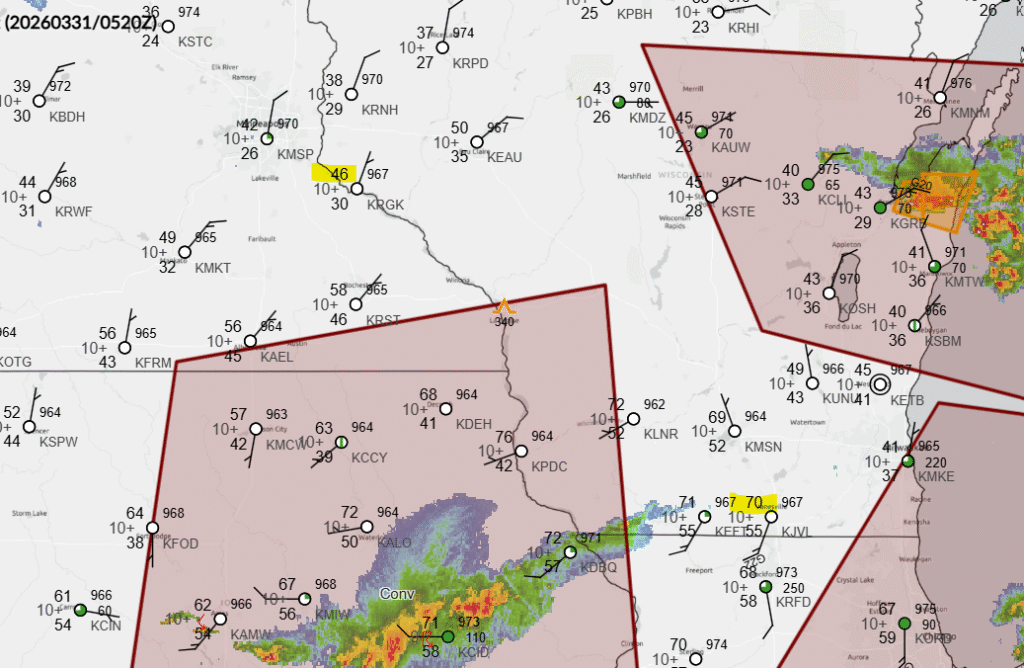
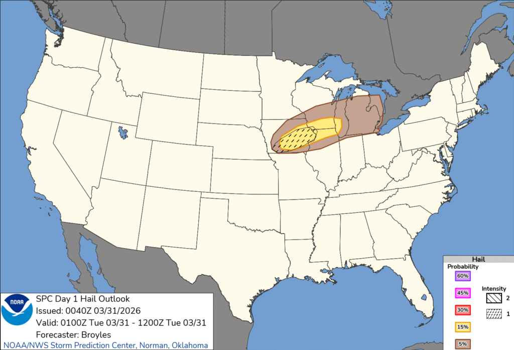
10:34PM: The SPC does have a hatched area on this evening’s outlook. Here is the hail forecast for you to see the new graphics in action.